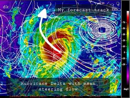
Wednesday Night 9:00pm CDT
After weakening over the Yucatan Peninsula Hurricane Delta is re-strengthening after emerging over the Gulf. Current central pressure is 977mb and max sustained wind speeds are 75-80kts. I expect the strengthening trend to continue though, likely becoming a major hurricane again, threatening SW Louisiana by this weekend (Always refer to official info for protection of life and property).
Convection is re-firing in the northern periphery of the central circulation and quickly pivoting SW/S. The resulting latent heat release is sampled well in recent USAF recon (image below). A central dense overcast (CDO) is evident but microwave imagery depicts a tightening circulation/eyewall. This should support further strengthening.
The circulation is still stacked and looking at the cirrus plume aloft you can identify an anticyclonic outflow pattern. This supports effective mass removal from the central column and should support further pressure falls.
The steering pattern should push the storm NW tonight before it reaches a weakness in the ridge aloft and interacts with a synoptic trough. This is when it likely makes a turn N, then NE toward SW Louisiana. Although the water is somewhat cooler than where Delta was previously located, it will be tracking over an area where ocean heat content is maximized.
To summarize, Delta emerged over the Gulf relatively intact and most indications are that it will be able to re-strengthen for the next 36 hours. An increase in forward speed, especially as it interacts with the "capture" trough, could result in an increase in storm-relative wind shear which could serve as a limiting factor, but otherwise I suspect that Delta will manage to climb back to at least category 3 intensity. I'm also not convinced we don't see another onset of rapid intensification, in which case I wouldn't be surprised to see it reclaim category 4 intensity.


No comments:
Post a Comment