Saturday, December 30, 2017

Arctic Blast to End 2017

  Well, the previously advertised cold blast is upon us and it has not been fun. We've seen temps in the low single-digits with wind chill below zero here in Kentucky and just upstream temps were in the -20's and below. This is the theme and as cold as it has been, it will be getting even colder. How does Alaska, Mexico, and Canadian snow cover come into play you ask? Well, alright! Amplified ridging (anti-cyclonic/clockwise flow) both near Alaska and off the coast of western Mexico aid the development of a deep trough over central Canada and the eastern U.S. This means that the jet stream (Polar Front Jet) dives further South over the eastern U.S. Snow cover in western/central Canada aids the development and strengthening of high-pressure at the surface and these areas of high-pressure are able to tap into extremely cold Arctic air masses and basically bring that air with them as they build into the central and eastern U.S. The troughing over the eastern U.S also means that waves that develop in the atmosphere and can produce different forms of winter weather have a favorable track to impact the central/eastern parts of the U.S as they hitch rides along the jet stream. We will be locked in this pattern until the blocking ridges near Alaska and Mexico begin breaking down. This will happen eventually of course but I think it won't be until we're a week or more into 2018 when we get the chance to thaw out and flatter flow aloft brings more "normal" cold weather. 
Current setup showing a blocking ridge near Alaska, another near Mexico/SoCal, and the associated troughing in the eastern CONUS, helping drive the Polar Front Jet southward. (Map Retrieved from University of Wyoming, Analysis by Myself)


Let's walk through the weekend forecast and see how things look for New Year's. I'll go ahead and say this and odds are you'll see more occasional rants from me about this in the future, I have seen countless people posting a forecast model graphic of their choosing on various sites and saying things like "HUGE SNOWSTORM possible for New Year's!" and "Nor' Easter to slam the East Coast!" or, on the flip side of this, things like "There won't be any snow" and "The snow/ice event in the southeast will NOT happen!". To "couch" what I'm about to say I guess I should point out that I am absolutely not model bashing nor am I bashing people who use them. I'm not even bashing people who post occasional model graphics online because I have done that myself. To the contrary I understand that forecast models are a necessary tool. What I find myself getting frustrated with is when some people post these images without providing context or worse, just taking them at face value with no real "forecasting" at all. What I mean is that it can be beneficial if people seeing these posts also understand that there are countless other models with countless other possibilities or that they understand, at least in conversationally-friendly language, some of the processes a particular image represents. I also get frustrated when it seems that someone completely skips the forecast process and goes straight to model analysis. Let me reiterate that I do NOT hate the computer forecast models, they're absolutely invaluable, I have just learned that if you can only "forecast" based solely on model output then you're destined to live or die by them, so to speak. Personally, the way I like to forecast is by first analyzing and diagnosing the current state of the atmosphere. This is just looking at what is going on and determining why it's happening. I use everything from the ridiculously awesome new GOES East (GOES16) satellite to my own hand-analyzed observation maps. After looking at how things were leading up to a given day and how they are at that time it's possible to develop a general forecast for the near-future, before you've ever looked at the latest HRRR run. Of course there are different things that one would look at for different situations and we will cover those with time but that's how my forecasts start. Simply looking at what is going on now.
After a certain point however it becomes much more difficult to anticipate what will happen and this is where the models can really shine. I like to look at different models/runs and see what they agree on and what they don't and compare this to what I think will happen. If I see that the models disagree with either myself or each other, and they will, then I like to try to figure out where exactly they differ and why they can't come to the same solution. Is there something that it thinks will occur in the atmosphere that alters its output? Is it a result of the model's physics? I find that the more of these questions I can answer the better.
  Last thing and I'll move on. It's also okay to not know something and to say "I don't know what's going to happen...yet". We are constantly playing catch up with mother nature, whether literally chasing a storm, or forecasting, and mother nature doesn't always show her hand truthfully. I would much rather just tell you all that I'm not entirely sure what will happen yet but here's what I know right now and continuously fine-tune it instead of throwing some random data at you for 8 days out and hoping it's right.


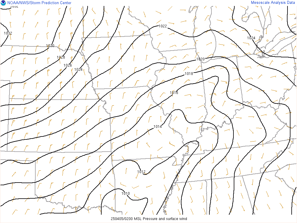
  Let's take a look at what's going on right now across the region. There is actually some snow ongoing in eastern Kentucky, mainly along and North of I-64. One snow band in particular from southern Ohio down through Lewis County was producing fairly heavy snowfall. Accumulations are expected to be light as this band moves eastward but hazardous travel conditions are occurring and slick spots will develop tonight. Back across northern and central parts of the State, minimal snow accumulations are possible as light snow showers pass through this evening, 0.5" or so, but the heaviest snow will be North of the Ohio River where the strongest forcing is located. 
Current analysis shows an upper-low just West of the Great Lakes with subtle wave passing through IL/IN right now (1730cst). Another strong jet is loaded upstream across the Northern Plains as it begins to work its way around the parent trough. At the surface, an area of high-pressure is centered over KY with a surface-low over the Great Lakes dragging a cold front through IL/IN. Another strong Arctic High is pushing into the northern CONUS right now and this feature will be a key player in our New Year's weather.
 Weekend Cold Blast 
  Throughout tonight and into Saturday morning a few flurries will be possible across northern KY as a subtle wave passes through but I don't expect much out of this. Models don't show anything from it but I don't feel cool saying there's a zero chance of a flurry so I figured a mention of snow flurries/freezing drizzle would be appropriate. Temps when you wake up Saturday will be in the low-mid 20's and will only be able to max out in the upper 20's, maybe 30, before a weak front passes through and gusty winds out of the Northwest spread over the area. Wind gusts will be in the 10-15mph range, I wouldn't rule out a few gusts over 20mph. Clouds will increase to overcast/mostly cloudy skies as the front passes as well before breaking up somewhat, to partly cloudy, from West to East following its passage.
  The passage of the front will mark the beginning of a true Arctic blast. That surface high that we said will be a key player really gets to shine at this point. It will serve as a streamline for the coldest air of the year to pour right into the region as it tracks Eastward toward the Great Lakes, keeping us under the influence of a cold North wind. Temps Saturday night/Sunday morning will drop into the teens with areas under more dense cloud cover in the upper teens.

New Year's Eve
  Frigid temperatures really arrive on Sunday, just in time for our New Year's Eve festivities (oh yay how fun). I think temps will top out in the upper teens. I'm not saying a few locations in southern Kentucky won't hit 20F, specifically locations that keep clearer skies during the afternoon, but pretty much everyone will be in the teens for HIGH temperatures. We should also see wind gusts in the 10-15mph range which won't help things in any way. Wind chill values are going to be in the single-digits. This is dangerously cold weather and I know many will be going out so just make sure you dress appropriately for temps this low. That might throw off your New Year's outfit plan but you've got to do what you've got to do. Lows Sunday night will quickly drop to single-digits and wind chill values will be below zero. 2017 ends like it started, cold, except it'll be about 20-30 degrees colder than it was on 1 January 2017, depending on what part of the State you live in.
  The good news is that it looks like Sunday will be dry. I have spent the majority of the time on this forecast trying to solve this very detail. Here's where I was tripping up. There is a jet streak/core of energy in Canada right now that is primed to round the base of the parent trough near the Great Lakes on Sunday given its current track. It will likely amplify slightly by then and cross the Ohio Valley. This is a common pattern to see, deep upper-level low sets up over the Great Lakes and a series of waves pivot around it and cross our region. This same exact setup brought respectable amounts of rain to the area just a couple weeks ago. Initially when I saw the jet streak and vorticity max (vorticity is basically a measure of spin in the atmosphere and it's commonly associated with producing lift) way upstream I made a note that it could be the trigger for snow locally. After analyzing this feature I dove into the models and, as expected, they show it deepening somewhat as it pivots around the parent trough and crosses into the region. However, pretty much every forecast model keeps the region mostly dry on Sunday. Now, waves pass through all the time and don't produce much of anything so this isn't crazy but I also didn't like the idea of saying it wouldn't snow because the models said it wouldn't (See what I'm doing here? Remember my rant?). That's where it pays to do your best Lt. Joe Kenda impersonation and get to the bottom of this. After analyzing more data it seems that there is a lack of moisture in the region, reinforced by the high-pressure at the surface (high-pressure is also associated with sinking air, not favorable for cloud/precip development, it doesn't mean you won't get clouds/precip but it requires another source of lift). The models are picking up on this drier air and that could be a reason for the lack of precipitation in their output. They also suggest a lack of, here's another technical term but I like this word, frontogenesis, essentially a tight converging temperature gradient which is often a source of forcing for ascent. Now it all seems to make sense and based on all of the available puzzle pieces I feel a little more confident. I do think a few flurries will be possible, particularly to our North, but overall I think this wave will lead to increased cloud cover for northern and central Kentucky on Sunday. As always I'll be watching this closely and if anything looks a little off then I'll make sure to address it. 

New Year's Day
  When you wake up for the first day of 2018, or are just going to bed depending on how you spent your night, temps will be in the single-digits for most of us. A few locations may make it to the low teens. Clouds will be clearing in the wake of Sunday's shortwave and skies should be mostly sunny. We will still be under the influence of surface high-pressure to our North and breezy northerly winds will keep things super cold. I'm thinking highs in the teens. Clear skies Monday night will allow temps to fall to single-digits again. Wind chill values will range from low singles to a few degrees below zero. 


I know this was lengthy but I wanted to cover a lot. I'm also hoping it's the last forecast I'll do for 2017. I'll have another post this weekend to get into next week's weather but that will be forecasting for the first week of 2018 so I'm hoping the next two days play out as expected and we can start talking next year without having to make adjustments. 
Speaking of 2018, there appears to be a chance for snow mid-week so that is what the focus of tomorrow's post will be. 
I really hope all of you have just an extreme amount of fun for New Year's. Stay safe and don't do anything stupid obviously but have fun. I'll be back tomorrow to discuss next week's weather and I'll also have a recap of my 2017 storm chasing adventures and stuff like that. 

Stay cool and stay warm...
DKK


Monday, December 25, 2017

Christmas Post!

  Merry Christmas!

  Hopefully you've had a fantastic day. Tonight we're going to take a look at what we might have to look forward to, or not look forward to depending on your disposition, as we finish up 2017. Spoiler, there could be a lot. 

Current Conditions Across Kentucky
  Right now (10:10pmCST) there are actually light snow showers working their way eastward across western parts of the State.
Most of this is not reaching the ground since there is relatively dry air in the mid-levels of the atmosphere (the dry layers work to evaporate precip as it falls through them). It is showing up on radar a little better now though so it's possible to see light flurries throughout the next few hours. No measurable accumulation is expected either way. It is also a very cold night with temperatures generally in the mid 20's across the area. Unfortunately I think we will see even colder temps in the not too distant future. The next few days will be cold no doubt but some of the data coming in has absurdly cold air to start 2018.
Blend of forecast models showing high temps, yes HIGH temps. for the start of the year.
  A few inches of snow could also be possible should this system progress as suggested. We have been locked in a very favorable pattern for winter storms and it looks to stay that way for awhile but it takes the right storm track and so far they have stayed to our North for the most part. You all know that I don't like to pretend that I know something I don't and I certainly don't forecast based solely on model data so I'm not willing to make any detailed forecasts regarding this event just yet, and besides, there are a few days to really hammer this out anyway. At the same time, there is relative consistency with the model solutions so it's worth acknowledging (Yes, the models CAN be consistently wrong so that's something I'm considering).
    I do have above average confidence in a significant shot of cold air as we close in on New Year's though and that will be a big story going forward. I think we will be seeing single-digit temperatures at times and perhaps even colder.
 

  That's the GFS suggested "surface" temps for 28 December. It shows a very strong high-pressure over the central CONUS with a streamline of unbelievably cold air funneling into the area. If you look closely you will see that it seems to think we will see temps 20-30 degrees below 0 across the Midwest. I should point out that this is just one solution from one model at one particular time and we look at many runs of many different models but it does a pretty good job of showing the consistently suggested setup going into the end of the year and I didn't want to waste your time with 10 different model graphics for 150hrs out (which is kind of far). A few things I'm looking at in the above image: I'm not sold just yet that we will see a 1060mb high-pressure system. That is extremely high, almost record breaking, and I personally think that is overdone. I'm not necessarily saying we won't see it either but the strength of that feature is instrumental in just how cold it gets because it directly determines just how much cold Canadian air gets tapped into as well as how far South it goes and I can not jump on that bandwagon yet. Again, I feel somewhat confident that we will see a relatively similar setup with a high across the central U.S but the small details make the difference. 
Here is a "spaghetti plot" showing multiple different model forecasts of mean sea-level pressure in the same time frame as the GFS image. You can see that there is some consensus on the general surface pattern but that's really about it. 

Basically, the moral of the story is stay bundled up, make sure family, friends, and anyone else you know is prepared for the possibility of dangerously cold temperatures, and stay tuned for frequent updates while we stay on top of this as things come together.
DKK

Sunday, December 24, 2017

Christmas Snow Update

 Many of you know this has been a much hyped forecast given the possibility of a white Christmas, some folks have even been "forecasting" for tomorrow and Monday for over 2 weeks and I have been mentioning it for several days, so with that in mind I wanted to do another update to cover my thoughts on what you can expect over the next 48 hours or so. I will be the first to admit that this has certainly not been an easy forecast but we don't do this because it's easy. There have been adjustments along the way, I personally have changed my mind privately probably a half dozen times, but remember that the goal is to GET IT RIGHT. Also, make sure to follow along with your local NWS office and other authorities regarding instructions during hazardous weather. I will always post my forecasts with the intention of providing more in-depth glimpses at the process of weather forecasting than you get with an app or "7-day graphic" on the morning news, with a much more personal feel, and I put the utmost effort into what I do. Furthermore, every forecast I post is one that I stand behind 100%. That said, I am in no way a replacement for "official" information and do NOT want to be seen as someone who thinks I can do what they do better than them. Honestly, I'm working toward doing literally the exact things they do. Basically I want this blog to be a complementary tool in your weather info toolbox. 
  I just felt that I needed to say that. Back on track though. I'm sure you've heard about the possible snow in Kentucky for Christmas Eve and Christmas Day and I'm sure you've heard different people saying different things. Here's what we're looking at: 

Will It Snow At All?:

  Yes! I am pretty confident we will see snowfall across the most of the area beginning Sunday PM. Particularly areas along and North of the Western Kentucky Parkway with greater accumulations along/North of I-64. South of the WK Parkway will see snow in my opinion but I think that slightly warmer temps and a warm layer above the surface will delay the transition from rain to snow while locations North should see more consistent snowfall. This snow will move into Western Kentucky by early afternoon tracking Eastward throughout the day before exiting the region overnight.There may be lingering flurries early Christmas morning. 
  I also think we may see another shot of snow Monday night through Tuesday morning as an upper-level jet max passes over the region but this is more "low confidence" right now since I haven't seen any model data whatsoever suggesting accumulating snow during that time frame but it's worth mentioning since I see some analysis that suggests dynamics would support it. Obviously I'll address this more tomorrow. 

How Much Will "Stick"?:
  
  This has been an area of debate among many. The greatest snowfall accumulation is likely along and North of I-64 where about 1" is expected. I think we will see slightly more than that around that area as "convective snow squalls" seem to be a high possibility, locally enhancing snowfall totals. Any areas that see these heavier bands develop should see about 1"-2" of snow. I'm thinking areas in central Kentucky may very well see accumulating snow as well and I wouldn't be surprised to see up to 1" near/North of the WK Parkway where any "snow squalls" develop. Overall it looks like less than an inch in this area though. 

How Will It Affect My Day?: 

  While this certainly doesn't look like a huge snowstorm by any stretch (at least for Kentucky) and will provide nice optics for your Christmas spirit, that doesn't mean it should be ignored. There will be hazards associated with it. Gusty winds will spread across the region and could reach 20-30mph at times so anybody traveling and caught in wind-driven snow, especially if they're in one of the previously mentioned "snow squalls", would have reduced visibility and impaired driving conditions. Also, temperatures will drop quickly below freezing as cold air associated with a cA (Continental Arctic) air mass funnels into the area and we lose the help from daytime heating (diurnal heating). Naturally slick spots will develop throughout the night. 
  As I said, enjoy the fact that you may get holiday snow but use caution if you are out and about because you'd hate to ruin your Christmas over something you could have avoided (and I'd hate that for you because that wouldn't be cool). 

So What's Going On Up There, How Do I Know ANY of This?
  Now that we've hit the main points I thought we could briefly touch on a tiny bit of the processes at play driving this event. For starters, I don't necessarily know exactly what will happen, none of us really know. Weather forecasts are literally a prediction of the future, and more than that, they are a prediction of highly variable conditions that are governed by insanely intricate and nuanced processes. All is not lost however. Through attention to detail, careful and meticulous analysis, constant education, and with the help of sophisticated tools developed by crazy intelligent people we can anticipate many of these events with fairly good accuracy and regularity. 
  With that "disclaimer" out of the way here's a short-ish version of what's up. There's a shortwave trough, which is basically a wave in the atmosphere, over the central United States right now. This wave is tracking this way. At the surface Kentucky is located between a large area of high-pressure over the central U.S and a low-pressure system off to our Northeast. This is essentially funneling cold air into the region. As the shortwave continues this way while simultaneously pivoting around the base of the parent trough (the longwave, original I know) it should amplify and strengthen, as they often do when entering the base of a trough. This will both increase wind speeds aloft and should increase lift downstream from it (assuming different temperature processes don't negate it!). Given that there should be enough atmospheric moisture to support the development of precipitation across the region, and there should be enough lift to make it happen, it becomes a matter of assessing the temperature of the atmosphere layer by layer to determine whether there will be rain, snow, or some combination. Ultimately most of the area looks like it will support snow with the exception of a few hours that I mentioned in southern KY. You put all that together and determine the liquid ratio of the snow (wet or dry snow), how heavy it will be (rate), and how long it will last (duration), and you basically have the method used to develop this forecast. 
  I know that's a lot but I thought it would be useful to know a little bit about what can go into any given forecast as well as informative to know a little bit about the weather pattern that's determining what you're going to see on Christmas 2017.

I really hope you enjoyed this and more importantly I hope you have a safe and awesome Christmas. 
Later...
DKK

Friday, December 22, 2017

A Wet Weekend and Christmas Forecast

FLASH FLOOD WATCH for South Central KY, Central/West TN, Central AR, Extreme East TX, and North LA thru Saturday 22 Dec
  
Heavy Rain Likely Friday-Saturday, Flash Flooding Possible!

Hey everybody! It's a little late tonight to be writing a forecast and blog post but I have been Christmas shopping all day (You know how that goes) and with so much going on this weekend I didn't want to wait until tomorrow morning, so I decided to do this now. Hope you enjoy! Today managed to warm up into the 50's despite heavy cloud cover. Overnight temps will hang out in the 50's, and I think actually even climb a little through as winds increase from the South and clouds stream into the area in advance of an approaching system.
I should mention that even now there are several model inconsistencies regarding the timing of key features which means different model suggestions for the start of rainfall, the end of rainfall, how much rainfall we'll see, and even whether it will be rain the whole time or change to snow. As always, my forecast is based off of detailed analysis of observed conditions, both here and upstream, and constant scrutiny of many computer models/model runs in order to come up with the most accurate forecast possible. I always like to let you know how confident I am about different aspects of my forecasts and, unfortunately, confidence really drops after Saturday. Should conditions evolve unexpectedly then they will be acknowledged and addressed. Now, there are certainly a couple headlines to cover over the next few days so let's get to it:

 
Friday 22 December:
  Temps when you wake up Friday morning temps will be in the low 50's, aided by southerly surface winds around 10-15mph (warm air advection). I think temps will make it to the upper 50's by the afternoon. As mentioned, the big story will be the heavy rain that's expected across the region. We may see a few showers during the early morning as a mid-level jet streak passes over the region but the "main event" will begin in the afternoon. Once it starts it will pretty much be here until Saturday afternoon. Rain will be heavy at times compounding its impact on holiday travelers so be careful and account for heavy rain and wet roads if you're out.
  The risk of severe weather is low but I wouldn't be surprised to see a few embedded thunderstorms throughout the day since there is are indications of some instability across the region. This instability will be very weak most likely but strong moisture advection could aid destabilization somewhat. Wind shear values are actually quite impressive as well so that's another reason I think a few embedded cells will be capable of gusty winds and occasional thunder.
  The main impacts however will be flash flooding and heavy rain leading to hazardous driving conditions. Current official forecast amounts have between 2"- 4"across much of Central KY, with 1"-2" North of the Western Kentucky Parkway, and higher totals South of it. I think some locations will see slightly higher totals approaching 5", especially near the TN/KY border up to Bowling Green. Rainfall totals like this may lead to flash flooding of streams, creeks, and perhaps roadways and parking lots with poor drainage so, again, be aware of these possibilities if you are traveling.
  Temps Friday night thru the early AM Saturday should cool to the mid-upper 40's.

Saturday 23 December:
  Rain will still be ongoing Saturday morning. High temperatures will range from the mid-40's in central/western KY to mid 50's along and East of I-75. This is one of those tricky scenarios as there is general model disagreement regarding the location of the cold front. Naturally, areas West of it will be cooler but the trick is determining how fast it passes through the region. Currently I think it will be draped across central KY by early Saturday afternoon allowing substantial heating in eastern parts of the State. Based on strong southerly flow ahead of the front I feel that mid-upper 50's are realistic temps east of the cold front Saturday (model data is suggesting 60's but rain/cloud cover should moderate that somewhat so I adjusted my forecast).
  Some model data is suggesting a brief transition from rain to a snow/rain mix as the upper wave passes immediately behind the front and takes advantage of remaining moisture in the atmosphere but I personally think it will remain North of the Ohio River. Even if this were to occur there would be no impacts. Rain will end from West to East as an upper-low finally crosses the region.
  Regardless of when the front passes one thing is clear, much colder air will pour in behind it. The coldest air will surge in from the North/Northwest on Sunday but temps overnight Saturday will still make it down to the 30's.

Sunday 24 December Christmas Eve
  Sunday morning will be much colder than the previous few days and I think some locations will see temps drop into the 20's. Strong high-pressure will be off to our West and surface wind will be out of the North. This will limit high temperatures for our Christmas Eve to the upper 30's, maybe reaching 40 or so max. This high-pressure at the surface will reinforce the Arctic air moving into the region and will lead to very cold, perhaps sub 20's, temperatures to start the week.
  The big thing to focus on for Sunday is a mid-level shortwave trough that is expected to pass over the Ohio Valley. This is where many of the model inconsistencies exist but the consensus for now is that when this wave swings through the area it will be enough to produce light snow showers Sunday afternoon. Indications are that less than a half inch of snow will accumulate, particularly in far eastern KY where terrain may enhance lift. Snow showers with little to no accumulation are also possible along and North of the WK Parkway.
 Hopefully Santa reads this forecast because he, and you of course, will need to bundle up for Christmas Eve night/Christmas morning since lows Sunday night will quickly drop to near 20 degrees. Any roadways that managed to receive any moisture may develop slick spots.

Monday 25 December Christmas
   Light snow flurries may still occur during the early AM. Temps will still be in the low-mid 20's when we wake up Christmas morning. Highs will eventually reach the low-mid 30's throughout the day under partly cloudy skies. Otherwise not too bad. Everyone enjoy your Christmas!

DKK


Sunday, December 17, 2017

Sunday Showers and an Unsettled Pattern Ahead

 Showers Today, Mid-Week Warm Up, Late Week Storm Chances, Uncertain Christmas 


We've got a showery Sunday across the region. NWS Louisville mentioned the dry mid-level air limiting the efficiency of rain reaching the surface and based on current analysis data and radar images showing scattered light rain I certainly agree with that. Interesting to note that there have been reports of sleet mixing in with rain as well, which is realistic given the current environment. No impacts are expected since surface temps are simply too warm. Expect a rainy day to continue through the afternoon with areas of light drizzle possible through the night. Lows tonight shouldn't drop too much since I don't expect the clouds to go anywhere so it looks like overnight temps should be around 40º.
  Monday: Highs should reach the low 50's across KY with southerly low-level winds advecting warm air into the area. I do think cloud cover will be hanging around tomorrow so that cloud keep highs down a little bit but warm air advection will still be the theme. Lows Monday night will be in the upper 30's-low 40's as stubborn cloud cover keeps things insulated. 
  Tuesday: Similar start to the day with warm air advection/southerly low-level winds ahead of a weak front. All in all I'm thinking we won't see much rain from this system but scattered showers are possible. Highs should reach the mid 50's before the front passes and West/Northwest winds bring in cooler air. Overnight lows should drop to the upper 30's and high-pressure will build in leading to clearer weather for the next day or two. 
  Wednesday: Despite Northerly low-level winds I think highs should reach 50 or so since it will be much sunnier than now and daytime heating should be maximized. Of course clear skies will also allow overnight lows to drop as well so lows should have no trouble dropping to near freezing/32º. 
  
Thursday into the weekend is where things really begin to get unsettled AND uncertain. Upstream developments across the central Plains on Thursday will play a key factor in our holiday forecast. I want to point out that I will definitely be posting updates frequently because, the truth is, we just don't know for sure how the small details will play out and things seem to change with every observation and model run. 

A strong low-pressure system will likely develop along the East side of the Rockies. This low-pressure system will slide eastward dragging a warm front across the region and a trailing cold front behind it. Thursday and Friday should be fairly warm and temps will flirt with 60º. I think we may see thunderstorms during the Thurs-Fri timeframe and I'm not willing to rule out strong-severe storms. Wind fields should be relatively amplified, providing sufficient wind shear, and if daytime heating & moisture return reaches the potential I expect then there could be some destabilization. Storm chances would be increased if the front is favorably timed (passes during max destabilization).

(Current model data showing different possible positions of upper air & surface features for Christmas. Notice the spread and inconsistency)

Then we move on to the Christmas weekend forecast, which is riddled with even more uncertainties. Honestly, there are too many possibilities right now for Christmas weather so, unlike some, I'm not going to pretend that I know what will happen. Model guidance isn't any help right now because there are so many inconsistencies you can find a model that suggests any type of weather you want that far out. What I do know is that colder air will stream in behind the front and will be deep enough to support wintry precip. Some models have been very consistent with snow chances for Christmas Eve/Day. Some have been very consistent keeping us dry. It's anybody's guess which to believe. I will say it's important to follow along closely as we get closer and confidence increases because there is a real possibility for winter weather affecting the holiday weekend, especially if you're traveling. 
DKK

Wednesday, December 13, 2017

Windy Wednesday Analysis

Current Hazards 
Strong wind gusts up to 40mph expected across the Kentucky during mid-afternoon. 
Red-Flag Warning in effect along and East of I-75 in Kentucky for increased fire danger.

 A frigid morning is actually shaping up to be a mostly sunny afternoon with highs in the upper 40's and possibly even some 50's in far western Kentucky, but you wouldn't know it thanks to the wind. Regional observation sites already show sustained winds in the 10-15mph range with gusts of 20-25mph. A strong upper-level trough/deepening surface low is currently crossing into Illinois and is on track to pass through the Ohio Valley, just to our North, this afternoon. This system will bring a trailing cold front across KY and winds will continue to increase as it approaches from the WNW. As we get into the mid-afternoon we should see gusts of about 40mph.  Wind gusts like this will no doubt blow loose outside objects around (ex: Christmas decorations, lawn furniture, etc) and make travel difficult, particularly for high-profile vehicles traveling on East-West roads (as outlined in the Wind Advisories issued by NWS Louisville and NWS Paducah). The strongest gusts will occur during 12-5pm CST before weakening around the evening. NWS Jackson has issued a Red-Flag Warning for areas along and East of I-75 until 9pm EST to address the increased fire danger from strong winds and a dry environment.

  Looking at radar right now and the heaviest precipitation/snowfall is over Ohio, North of the warm front. Just a little tidbit, the precipitation across Ohio is due to what's referred to as isentropic ascent or "over running" where the warmer air South of the warm front rides up over the cooler air ahead of it. This lift eventually leads to cloud and precip production, assuming the moisture and thermodynamics are in place. This differs from the focused lift you may see associated with, say, a cold front. With a cold front you often see the colder air behind the front lift the warm air ahead of it and the result is, many times, a more narrow band of precipitation as opposed to the clustered nature of "over running". Anyway, back on track now. I'm leaning toward a dry evening forecast for Kentucky. Analysis shows dry air established across the area and with no clear mechanisms to moisten the environment in the short-term it seems we will see a "dry front" pass, with increased cloud cover and a wind shift from S/SW to W/NW this evening being the most obvious signs of the strong upper-trough and cold front.
  I do want to acknowledge the model data because the high-resolution guidance has been suggesting light precipitation (rain) passing through eastern KY this evening and has actually been pretty consistent with the last several runs, even the overnight runs.  It seems the models have overdone the moisture a little bit based on actual observations but it's worth noting.  If they verify then a few scattered showers would be possible in far eastern KY but again, observations support a drier evening.
  Once this current system passes high-pressure will build in behind it keeping things quiet for the next day or two.  Highs on Thursday will likely be in the mid-upper 30's and lows will be in the low 20's. Skies will be partly sunny, transitioning to mostly cloudy into the late evening as winds shift to northeasterly.
  Friday will be similar to Thursday with highs a few degrees warmer since wind will be out of the W/SW. Lows will be in the mid-upper 20's but I'll be watching trends for overnight lows as clear skies could allow a little more cooling to lead to lower lows.
  Slight warming trend continues Saturday as wind will again be out of the SW allowing somewhat warmer air to move in.  Forecast data suggests upper 40's for highs but I wouldn't be surprised to see a few places hit 50 given likely clear skies. Lows will be in the upper 30's on Saturday night.
  Cloud cover will be increasing Saturday night in advance of our next system which will move through Sunday. I'll be covering Sunday's weather soon as there are still some uncertainties but there is a chance for rain and snow showers throughout most of the day on Sunday.
Stay warm everybody and I'll be back soon!
DKK

Tuesday, December 12, 2017

Tuesday Morning Update

Snow Showers and Wind Gusts up to 30-35mph Expected Today
Light Accumulations Possible Primarily East of I-65


  Good Tuesday morning! I'm trying to be quick because I'm out and about this morning but I want to address today's weather. There are a couple main issues to be aware of today. The first is possible snow showers and freezing rain, the second is strong winds as 30+mph gusts have been measured at observation sites across the State.
  At this time regional radars show  scattered precip with light rain showers transitioning to snow flurries from East to West.
As strong northwest winds continue to pour into the region these temps will remain cold and wind chill values will be in the teens. I think light rain in central KY will transition to snow within the hour or so as temps cool to below freezing. Environmental soundings upstream show enough moisture and instability to support snow production although the best overlap of ingredients and timing will be in eastern KY. Be cautious as slick spots will be possible, mainly on elevated surfaces (road temps are currently near 40ºF). These will clear out of central KY by early afternoon.
  As mentioned, the greatest chances for accumulating snow, up to 1/2-3/4", is east of I-65. There will actually be two separate shots, the first this morning with a passing cold front, and another through the afternoon as an upper-trough passes. A few heavier snow showers are possible given more favorable environmental profiles and terrain assistance in eastern KY. Snow showers and strong winds means visibility may be reduced significantly at times so use caution when out.
  The upper-trough is on track to exit by late afternoon and the cold air will be well established. Temps will be in the low 20's/upper 10's tonight and places in eastern KY could see mid 10's.
  The pattern looking ahead still shows multiple waves passing through the region. Stay tuned for another post today which will address the week ahead in greater detail.
Current Wind Observations Across KY
Via Kentucky Mesonet Sites
Ohio County:26mph
Grayson County:29mph
LaRue County:32mph
Warren County:33mph
Caldwell County:28mph
Mercer County:19mph
Casey County:18mph
Taylor County:23mph
Madison County:23mph
Breathitt County:13mph

DKK

Saturday, December 09, 2017

Weekend Forecast/Look at the Week Ahead

 Saturday 9 Dec
KY Highs: Low-mid 30's
KY Lows: Around 20º, Upper teens in usual cold spots/E KY
Light Snow Showers Central/East KY, 1/2" psbl along/near I-64 (Timing: Late AM-PM)
Gusty Winds up to 30mph

Sunday 10 Dec
Highs: Upper 30's North/Low 40's South
Lows: Mid-Upper 20's
Partly Cloudy
W/SW Wind at 10-15mph


 Good Saturday morning everyone! I'm excited about the opportunity to write these posts and hope you enjoy them. I'm so excited that I'm actually doing this forecast while riding in the car this morning.
  First thing, as you know it is cold cold cold. Observations are in the low 20's across the state and I've got a decent snow shower in Elizabethtown right now.
Greatest chances for accumulating snow looks to be in eastern KY, along and near I-64, where a 1/2" may be possible. Elsewhere, trace amounts are expected at most. Dry air is the main limiting factor for more snowfall but should it seem that flurries are more efficient than expected then 3/4" could occur in eastern KY.
  Also worth noting, a very amplified jet stream is over the eastern half of the U.S. with a speed max (core of stronger flow) over WI/MN at 12z (6am CST). As this streak and the wave it is associated with pivot around the parent trough and into the Ohio Valley gusty winds should occur as a response. Upstream observations and model guidance suggest gusts around 20-25mph and I think 30mph gusts are possible accounting for momentum transfer to the surface. As this wave passes this afternoon/evening snow showers/flurries will exit from W-E. Temps will drop to around 20º for overnight loss but I think usual cold spots will see some temps in the 10's.
  Sunday looks to be dry with partly cloudy skies across the region as Saturday's system exits the area. Winds will be from a more southerly direction so that should help get temps up a little, particularly in central & southern KY where I think we'll hit the 40's. Lows Sunday night should be only a few degrees warmer than Saturday night.

A series of waves are expected to pass throughout next week. Monday could bring a little relief from the frigid cold but only briefly. A short-lived warm air advection regime looks likely ahead of our next possible system and I think we could see temps reach 50 Monday afternoon. By Tuesday I think our next clipper will pass and bring another chance for snow showers. Temps will bottoms back out fluctuating between highs in the 30's and lows in the 10's-20's throughout the week. Data is showing precip/snow chances increasing by next weekend as yet another clipper crosses the region so we'll cover that in more detail soon.
  Thank you very much and I'll be back on soon. Feel free to contact me with any questions. Also, keep checking back as I'll be adding new features regularly.
DKK