Man ole man, what a tricky forecast for the next several hours. This is going to be a fairly brief post today so I apologize if it lacks the usual detail you're accustomed to reading on this blog. I'm currently sitting here in my office awaiting storm development later this afternoon so I don't have too long to type this but we'll look at some of what we're working with. This is NOT a banner chase day as there just isn't too much that's favorable for organized severe weather but it's a local setup so I'm going to take a chance on some "mesoscale magic". Uncertainty is also extremely high for today and the model guidance has no run-to-run or model-to-model consistency either so there isn't much ability to even fall back on the models as a last resort to reign things in. All is not lost though and I think we can still develop a reasonable forecast based on what we do have so let's get to it.
Starting with a quick look aloft we can see that upper-air support is weak today. Higher heights/ridging are in place over the Ohio Valley/Great Lakes with an upper-low upstream over Nebraska and a convectively-aided shortwave over Oklahoma. A core of 30-40kt 500mb W/SW flow is over northern Indiana/Ohio/, central Illinois, and back into Missouri. This isn't particularly strong but it's sufficient to help with some degree of updraft organization. I think the better deep-layer shear is going to be displaced to the North of the moist sector but there could be some overlap in southern Indiana/Iliinois and particularly in the Missouri bootheel where colder temps aloft (-10 to -12C) will steepen lapse rates a bit more.
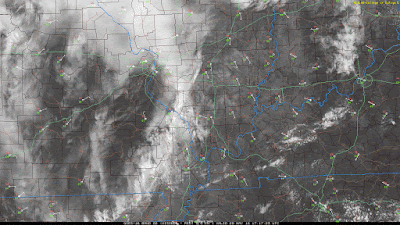
A complicated surface scenario will be a key player this afternoon. A weak, 1016mb surface-low is centered over northern Missouri with a slow/stalled front extending eastward through Illinois/Indiana and a cold front extending southward through Oklahoma. The moist sector is characterized by mid 60's dew points spreading into central Illinois/Indiana and upper 60's-low 70's into Arkansas and PWAT of 1.5"-1.7" through central Missouri. An army of outflow boundaries are also evident after a combination of radar, satellite, and surface obs analysis. This is a huge complicating factor as they are difficult to identify in some cases. There is one that is particularly noticeable in southern Illinois/Indiana tracking SE into the Owensboro, KY area and another in SE Missouri tracking SE. This air mass is currently convectively overturned and strongly capped. A plume of marginal, but "good enough" mid-level lapse rates (6.5-7C/km) are spreading across the area and some destabilization of the boundary-layer is destabilizing somewhat. RAP derived MLCAPE suggests 1000j/kg throughout the moist sector with an axis of 2000-3000j/kg (may be a little aggressive) over eastern Arkansas.
I have to quickly hit on target areas and hazards and then I have to go so forgive the rapid ending. Convective initiation may seem "random" in some cases (it's not actually "random" but may appear that way). It's difficult to anticipate where initiation will occur for sure but I have identified a few areas where it seems most likely and where the environment is more conducive for sustained convection, perhaps severe weather.
We'll most likely see continued elevated showers and storms due across the upper Ohio Valley due to isentropic ascent North of the surface front. I expect we'll see scattered storm initiation along various outflow boundaries throughout the day and that will be more favorably timed with peak diurnal heating to support some stronger storms.
I had intended on targeting southern Indiana but given the extent of overturning of the air mass in that area I have decided to target western Kentucky. The SPC has been maintaining that the Illinois/Indiana is more supportive, and perhaps they're right given better shear, but I'm not so sure initiation occurs there and I feel better across western Kentucky where more unstable air is surging into the area and capping is weaker/weakening. The current position and motion of two more evident outflow boundaries also leads me to believe these are more predictable areas of storm development. Hazards will be marginally severe hail and damaging winds. Tornado risk is low today so I'm not expecting much in that regard, but these situations with intersecting boundaries and terrain influences can cause localized rotation and if an updraft is able to ingest that vorticity and redistribute it to the surface then there becomes an outside chance at brief circulations/non-mesocyclonic tornadoes. Weak storm-relative mid-level flow suggests that a messy, multicell storm mode is most likely. The organization/consolidation of cold pools is another question mark as this could result in continued updraft development and growth into linear/bowing segments.
All in all I'm not expecting a big day but I'll be in western Kentucky seeing what happens. I still think that's the most likely area, along with western Tennessee, to see strong storms so we'll see how the outlooks address this in the next 6-8hrs.

