It's pretty late tonight and I've been looking over everything I can trying to put together the pieces for this weekend's setup and I thought why not go ahead and try to dive into it with everyone for a bit. I will be breaking everything down in a lot more detail Thursday night because I expect to have it all narrowed down even more over the next 24 hours but I'm confident enough to at least get into it so let's go. Side note: Although I will do the usual "target forecast" blog post within 18 hours of the event the reality is that I'm likely not going to have to go far at all since I have a feeling based on how it looks to me that my driveway will be the staging point while waiting for initiation. I think supercells will be likely and tornadoes, large hail, and damaging winds are very possible. Currently the plan is to be patient, see how things set up, and once CI (Convective Initiation) seems imminent position just East then ride along with the storms as the greatest dynamics come into play, stair-stepping southward if needed.
First of all, it's my first chase since the end of June in the when we chased everywhere from South Dakota/Minnesota to Kentucky to the Oklahoma/Texas panhandles so it's nice to be back in the saddle. I've been busy with college but there hasn't been much more than diurnally-driven Summer storms anyway, save for a few supercells tonight in Nebraska and occasionally some stuff up the Atlantic Coast. Currently the SPC has delineated much of western Kentucky and southern Indiana/Illinois in a "slight" risk for severe weather but I fully anticipate this will be upgraded by Thursday or Friday (as of typing time of 10pmCDT). Do not discount the threat regardless though because this is just my opinion based on my own analysis. I think the greatest challenge is outlining the areal extent and duration of severe weather. I also want to mention that there is always increased anxiety when it looks like my home and family/friends are in the same area I'm targeting for dangerous storms so I certainly want them to be paying attention as well. It's not that I'm not anxious when I'm chasing anywhere else in the Country for the folks involved, just that anxiety is even higher when I'm out chasing and trying to watch everyone I know at the same time.
Current Analysis
Regular followers know that I always like to start a forecast by looking over what's going on in the here and now. I know I probably spew this to you guys until we're all blue but it's just how it is. That said, since I'll be updating things again in the final target area post Thursday evening and in the purpose of brevity I'm not going to post every single thing I've been looking at but I'll post a few keys that sum up the current pattern.
 |
| Current radar imagery shows pretty intense convection over Nebraska and the Dakotas associated with our cyclone upstream. Some of these storms have been maintaining supercellular characteristics for awhile now with several reports of very large hail and even a few tornadic storms. Elsewhere, we can see scattered convection lingering along a stalled frontal zone across the southeast CONUS. Much of this activity is dissipating at this time. |
 |
| Above is the 0z 250mb obs. We can easily pick out our upstream speed max associated with a relatively far southward dive in the Polar Jet as it flows across the Pacific coast and into Nebraska. It's a fairly amplified streak with a core of 80kt flow. It's not the 100kts or more you expect in the "cool season" but sufficient nonetheless. We can also see a broad ridge over the SW CONUS and a pronounced trough over the NE. These features will serve to provide the general track for our mid-level wave. |
 |
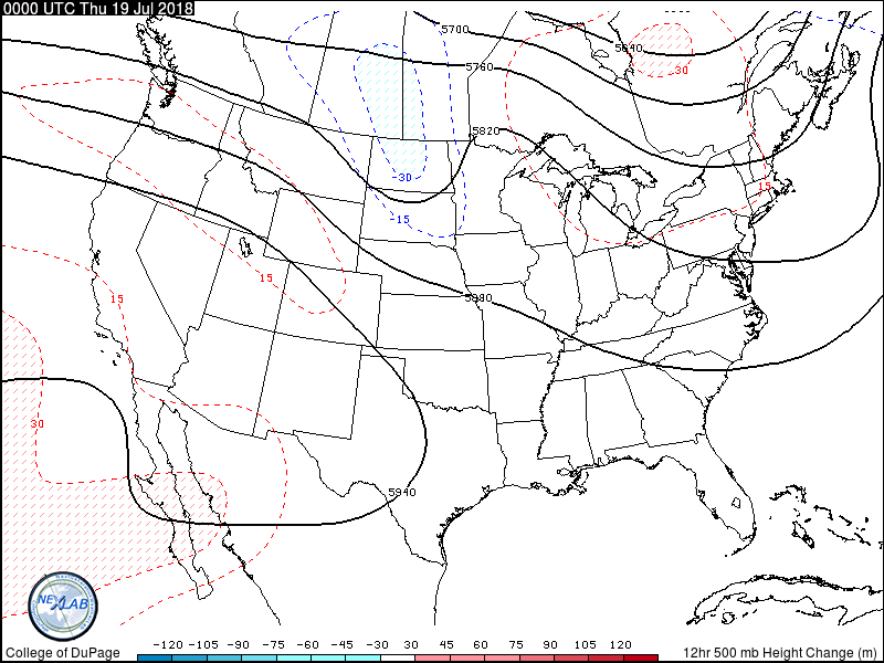
| Dropping down to 500mb, pictured above. Our shortwave trough over South Dakota is evident with a 50kt speed max entering its base at 0z. This speed max will play a big role Friday I belive as we often see very strong instability but weak shear during the "warm season" but this will help procide plenty of shear for more organized storms. I expect this shortwave to amplify further, given the fact that the jet streak is still located in its upstream region. It should track generally East as it is steered by the ridge over the SW and trough over the NE, before eventually phasing with the deep eastern trough this weekend. |
 |
| This is the geopotential height tendency over the past 12 hours. This is just a good resource to asses the amplitude of mid-level waves as well as track their movement, and areas of height falls can also be linked with ascent given the temperature advection process that occurs. 30m falls isn't particularly strong at all but this shortwave just recently developed and has yet to mature and undergo intensification so I think greater height falls will overspread the Ohio Valley on Friday. I have been tossing around the idea of doing a detailed tutorial on dynamics such as this but just haven't had the time. One day... |
 |
| We'll drop on down to 850mb now. In the Summer moisture is rarely an issue but I don't think it's a good idea to leave anything to climatology. I'm pretty sure a major goal of forecasting is to out perform climatology actually so we should assess moisture quality. We can see the middle bound of our surface-low associated with our developing upper-low over SD with a strong area of high-pressure over the Ohio Valley. Deep moisture, in many locations over 16C, extends well into the central plains after rounding the periphery of the high-pressure system and surging through the warm sector. A strong temperature gradient associated with the frontal zone aloft is also evident. |
 |
| This is just another product I like to use to assess moisture. My favorite product is mixing ratios which is the ratio of moisture in grams per kilogram of air but this is precipitable water (PWAT) and is a parameter that attempts to calculate the amount of precipitable water in a vertical column. PWATs of 1.5" extend up into the Dakotas with very high PWATs of 2"-2.2" still waiting to be tapped into in the source region. |
 |
| Now we get to the surface. I will try to post my manual hand analysis for the next blog but since it's already late it was just way easier to copy the WPC analysis. It's worth pointing out that there have been some pretty major storms over Nebraska this evening so there are some influences of that in the obs. We can still see our 1008mb surface-low over South Dakota with a narrow warm sector. That is heavily modified by convective reinforcement of the frontal boundaries. A stalled front extends East-West across the SE into TX/OK near the Red River. Like I said, moisture isn't expected to be a problem in terns of how much moisture exists but rather determining where it will end up over time. We've got 70+ dew points across much of the southern and central CONUS, only suppressed where the area of high-pressure is sitting near the Great Lakes. 1008mb isn't terribly deep but as the shortwave deepens and temperature/moisture gradients tighten this low will deepen a few mb as well. This low is well connected to the trough aloft (meaning it's not a shallow system) so it will take a generally eastward track as well and this will lift a warm front northward and drag a cold front eastward. With the low progged to be near the Great Lakes by Friday we can infer that we'll have at least a narrow warm sector over some portion of the Ohio Valley. |
I'm not going to share a bunch of sounding analysis yet as I will do that in the next post but I like to analyze many observed soundings from the upstream air mass at this point.
We've already developed a solid conceptual model of what the general setup will be. Now part of the challenge is determining when/where/if CI (Convective Initiation) will occur as well as what the preferred storm mode will be. We'll look at some model data in a second but before we do let's review our setup. Understand that there's all of Thursday in between now and our event so I have had to forecast for it too as I wouldn't recommend forecasting an event without knowing what leads up to it because the overnight storms on Thursday could play a key role in how Friday plays out. (I could go on about how an overnight MCS in Kansas recently forced me to shift my target area about 90mi southward before finally seeing storms initiate along the dryline but I'll spare you).
We know we've got a shortwave over South Dakota sandwiched in between a broad SW ridge and NE trough with a slightly amplified speed max in its upstream flank. A surface-low and attendant frontal boundaries are located beneath this shortwave with deep moisture riding the periphery of a SE high-pressure area. Steep lapse rates are located over the central plains. Our shortwave will amplify and track generally eastward with height falls spreading over the Ohio Valley by Friday afternoon coincident with the exit region of a northwesterly 60kt 500mb speed max nosing into Missouri/Kentucky/Illinois. The surface-low will also track eastward toward the Great Lakes while establishing a warm sector across much of the Ohio Valley while the westerly component of flow aloft will draw the plume of steep lapse rates atop the warm sector. That's a typical severe storm environment: strong moisture extending well throughout the boundary-layer, steep lapse rates overlapping the warm sector, strong boundary-layer heating steepens low-level lapse rates and aids destabilization, speed max digging in with upper-trough providing sufficient shear profiles, focused ascent along frontal zone and large-scale ascent with jet streak exit region should provide enough forcing for CI.
Forecast: How Does This Go?
Enough of that though, you guys want to know WHY I think this setup bears chasing. As I said, we have already inferred that we'll have an environment certainly supportive of of severe storms. Even the models agree and have been pretty consistent both with each other and from run-run. The biggest trick is trying to anticipate how Thursday's storms will affect the setup. Strong-severe storms are expected to fire across Missouri and the Mississippi River Valley Thursday afternoon and these storms will track ESE. They will be crossing Kentucky through Friday morning and this may act to position the risk area a bit. Here's how I see it playing out though. These storms should likely be over central Kentucky by mid-morning on Friday and should be rooted above the boundary-layer by then when they'll clear I65. If this convection is stronger or weaker than anticipated or has greater/less areal coverage than anticipated then that could shift the threat area in either direction because this can affect the degree of destabilization. The corridor of steepest lapse rates aloft looks like it will be located primarily over western Kentucky into extreme southern Indiana and as it couples with deep moisture and strong heating (forecast temps near 90F) MLCAPE values should be in the 2,000-3,000j/kg range. The region should be relatively uncapped except for areas East of I65 where the morning convection may factor in. It seems likely that storms will fire by mid-afternoon as soon as low-level lapse rates steepen sufficiently, likely in Illinois and toward the Ohio River near the "tongue" of the theta-e axis after which they will track ESE into Kentucky where stronger thermodynamics and shear profile supportive of both persistent rotating updrafts and low-level circulations should result in primarily supercell storms until late evening when upscale growth seems more likely. The aforementioned mid-level speed max will be nosing into western Kentucky by noon on Friday and this will help increase deep-layer/effective shear to over 40-50kts. Although low-level SRH appears weaker during the early afternoon very strong buoyancy in the lowest level (0-3km MLCAPE over 200j/kg) as well as critical angles near 90 degrees and strong pressure pertubations associated with strong mesocyclones could compensate and support a tornado threat given vortex stretching and forecast hodos still show sufficient curvature with veering wind profiles, but the "golden hours" will be when the storms are likely in western Kentucky and the strengthening low-level jet will interact with supercellular storms in a already favorable environment and late-afternoon could pose the greatest risk for tornadoes. This is part of the reason this area is my current target. Be aware though that regardless of the tornado outcome any of these storms will be capable of large hail and damaging winds along with intense rain and dangerous lightning.
 |
| NAM3k forecast for 0-1km storm-relative helicity just as the LLJ is expected to be increasing. Values are forecast by this model to be in the 200m^2/s^2 range which is more than capable of supporting tornadoes. Values may even increase more as the LLJ intensifies. |
 |
| You can pretty much see the mid-level speed max in the model forecast 0-6km shear graphic as deep-layer shear will be supportive of organized storms where this core noses in. |
 |
| Pictured above is the NAM model trend for 500mb heights over the last few runs. There is general agreement but notice that it has been trending with a more amplified wave with each successive run (thicker contours=more recent run) |
 |
| This is a forecast graphic from the GFS model depicting the height tendency equation (Like the height falls graphic from earlier). Notice that it has an area of height falls spreading over the Ohio Valley preceding the trough as it moves into the region on Thursday night. |
 |
| NAM3k output for MLCAPE just prior to when CI is expected. You can see the heavy influence of the morning convection East of I65 with strong instability developing West of it. These morning storms are something I'm going to be following along with in real-time very intently because they could modify where this instability axis is located. |
 |
| MLCIN from the NAM3k model shows the stabilizing influence of the morning convection as well. |
A great deal will be riding on mesoscale details and I'm going to be very curious to see how the mesoscale features evolve so I'll be tightening up my chase forecast tomorrow as well as posting videos breaking down the threat so stay tuned because there's at least the potential for a substantial severe weather event.