Current Hazards
Strong wind gusts up to 40mph expected across the Kentucky during mid-afternoon.
Red-Flag Warning in effect along and East of I-75 in Kentucky for increased fire danger.
 A frigid morning is actually shaping up to be a mostly sunny afternoon with highs in the upper 40's and possibly even some 50's in far western Kentucky, but you wouldn't know it thanks to the wind. Regional observation sites already show sustained winds in the 10-15mph range with gusts of 20-25mph. A strong upper-level trough/deepening surface low is currently crossing into Illinois and is on track to pass through the Ohio Valley, just to our North, this afternoon. This system will bring a trailing cold front across KY and winds will continue to increase as it approaches from the WNW. As we get into the mid-afternoon we should see gusts of about 40mph. Wind gusts like this will no doubt blow loose outside objects around (ex: Christmas decorations, lawn furniture, etc) and make travel difficult, particularly for high-profile vehicles traveling on East-West roads (as outlined in the Wind Advisories issued by NWS Louisville and NWS Paducah). The strongest gusts will occur during 12-5pm CST before weakening around the evening. NWS Jackson has issued a Red-Flag Warning for areas along and East of I-75 until 9pm EST to address the increased fire danger from strong winds and a dry environment.
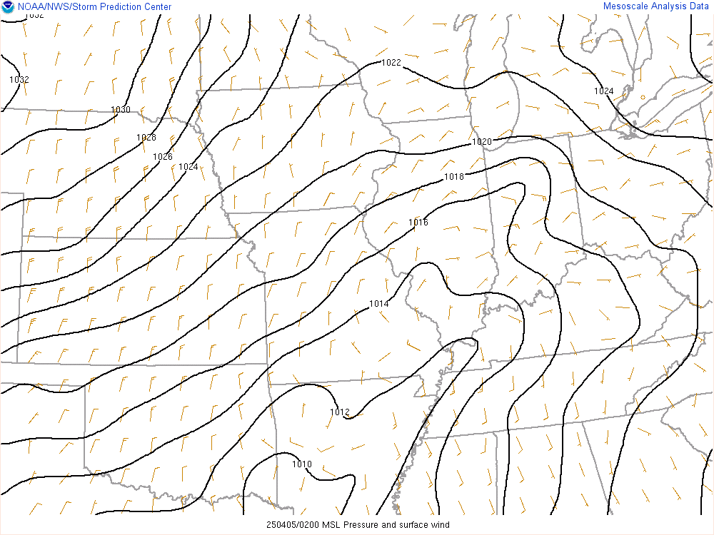
Looking at radar right now and the heaviest precipitation/snowfall is over Ohio, North of the warm front. Just a little tidbit, the precipitation across Ohio is due to what's referred to as isentropic ascent or "over running" where the warmer air South of the warm front rides up over the cooler air ahead of it. This lift eventually leads to cloud and precip production, assuming the moisture and thermodynamics are in place. This differs from the focused lift you may see associated with, say, a cold front. With a cold front you often see the colder air behind the front lift the warm air ahead of it and the result is, many times, a more narrow band of precipitation as opposed to the clustered nature of "over running". Anyway, back on track now. I'm leaning toward a dry evening forecast for Kentucky. Analysis shows dry air established across the area and with no clear mechanisms to moisten the environment in the short-term it seems we will see a "dry front" pass, with increased cloud cover and a wind shift from S/SW to W/NW this evening being the most obvious signs of the strong upper-trough and cold front.
I do want to acknowledge the model data because the high-resolution guidance has been suggesting light precipitation (rain) passing through eastern KY this evening and has actually been pretty consistent with the last several runs, even the overnight runs. It seems the models have overdone the moisture a little bit based on actual observations but it's worth noting. If they verify then a few scattered showers would be possible in far eastern KY but again, observations support a drier evening.
Once this current system passes high-pressure will build in behind it keeping things quiet for the next day or two. Highs on Thursday will likely be in the mid-upper 30's and lows will be in the low 20's. Skies will be partly sunny, transitioning to mostly cloudy into the late evening as winds shift to northeasterly.
Friday will be similar to Thursday with highs a few degrees warmer since wind will be out of the W/SW. Lows will be in the mid-upper 20's but I'll be watching trends for overnight lows as clear skies could allow a little more cooling to lead to lower lows.
Slight warming trend continues Saturday as wind will again be out of the SW allowing somewhat warmer air to move in. Forecast data suggests upper 40's for highs but I wouldn't be surprised to see a few places hit 50 given likely clear skies. Lows will be in the upper 30's on Saturday night.
Cloud cover will be increasing Saturday night in advance of our next system which will move through Sunday. I'll be covering Sunday's weather soon as there are still some uncertainties but there is a chance for rain and snow showers throughout most of the day on Sunday.
Stay warm everybody and I'll be back soon!
DKK