The possibility for severe weather across the region was mentioned a week prior to the event (SPC mentioned it in their Day 8 Outlook). Although predictability was low and significant uncertainties regarding the moisture return flow cycle following a frontal passage precluded any kind of delineation of a "severe risk", signals were there that a very amplified system would be somewhere in the vicinity. A very active pattern complicated things further as severe weather was also expected across the Ozarks/Tennessee Valley in the days leading up to 2 March and the environmental recovery from this would be critical. The forecast models showed their usual discrepancies at this range.
Details emerged over the coming days and the SPC introduced a "slight" risk for severe weather 72hrs out from the event (Note: At that time the categorical risk levels were General, Slight, Moderate, High).
 |
| SPC Day 3 Categorical and Probabilistic Severe Weather Outlooks for 2 March 2012 |
An initial round of convection was expected early in the day across the warm sector with another round along/ahead of the trailing cold front. Fast moving storms with potential for tornadoes were possible but there were lingering uncertainties regarding exactly how these storms would evolve.
A "moderate" risk was issued for severe weather on 29 Feb 2012 as well and several tornadoes were reported across Kentucky and Tennessee. This event did raise questions about how far North the most favorable environment for severe weather would exist, but given the expected deep low pressure system being forecast confidence was still high in a large scale severe event.
 |
| SPC Categorical Severe Weather Outlook for 29 Feb 2012 |
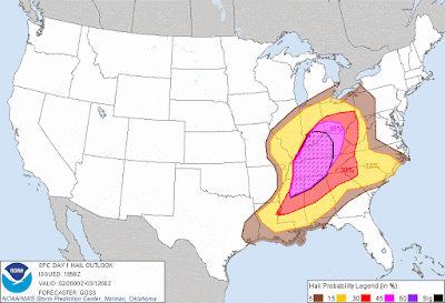
The SPC issued a "moderate" risk for severe weather valid for 2 March 48hrs out and things were falling into place unfortunately. The likelihood for supercells/supercell tornadoes was significant as it was noted by the SPC that "several tornadoes" were likely and some were expected to be strong/violent tornadoes.
From the SPC Day 2 Discussion:
THE STORM
   DEVELOPMENT SHOULD BE FOCUSED ON A ZONE FROM THE MID OH VALLEY SWWD
   ACROSS KY AND TN INTO PARTS OF MS AND NRN AL...WHERE RAPID
   INTENSIFICATION IS EXPECTED GIVEN THE FAVORABLE THERMODYNAMICS ALONG
   WITH SHEAR PROFILES VERY SUPPORTIVE OF UPDRAFT ROTATION.

   WITH STORM MODE LIKELY TO BECOME A MIX OF SUPERCELLS AND COMPLEX
   LINE SEGMENTS...THREATS FOR BOTH DAMAGING WINDS AND SEVERAL
   TORNADOES APPEARS EVIDENT...ACCOMPANYING THE LIKELIHOOD FOR LARGE
   HAIL.  A COUPLE OF STRONG TORNADOES WILL ALSO BE POSSIBLE -- MAINLY
   DURING THE MID TO LATE AFTERNOON HOURS IN AND NEAR THE MODERATE RISK
   AREA.
Going into the event the focus was a very strong trough forecast to move toward the Great Lakes with strong, and deepening low-pressure at the surface as a response. In turn deep moisture from the Gulf was expected to surge northward beneath steepening lapse rates and strong wind fields.
 |
Archive GFS guidance valid 0000UTC 1 March 2012 - 1200UTC 3 March 2012
Models were showing strong cyclogenesis with a deepening low-pressure system propagating northeastward across the Ohio Valley. |
-The Outbreak-
As the day began all the appropriate entities were reiterating the possibility of a "significant severe weather episode". The local NWS offices along with the SPC and local officials were coordinating information statements and outlooks while broadcast meteorologists were continuing to emphasize the need for the public to be alert and have a plan.
 |
SPC Day 1 Categorical Risk for 2 March 2012 (Morning Outlook)
|
The pieces were in place for a significant severe event, not good news for folk across the Ohio Valley and Gulf States. A broad warm sector that was very supportive of all severe hazards with numerous prefrontal storms expected to develop over the course of several hours.
Storms actually fired early in the morning as the warm front made its way northward through TN and KY with severe weather ongoing across Illinois, Missouri, and Indiana by sunrise.
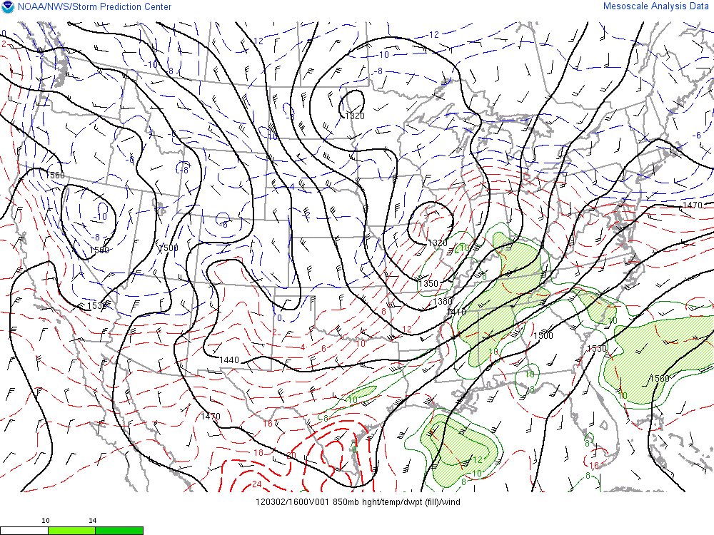
The upper-level pattern on 2 March 2012 was defined by a powerful polar-jet with a broad Pacific ridge, and troughing over the northern CONUS. 12z(6amCST) observations indicated a 130kt speed max at 300mb (approx:9,000m/30,000ft) exiting the base of the trough and crossing the southern Plains just upstream. A 70-80kt speed max was located at 500mb (approx: 5,000m/18,000ft) over the Texas panhandle into central Oklahoma. This would play a key role as the day progressed. Upper-level winds generally intensify during the "cool" season and weaken during the "warm" season so when the right small-scale ingredients come together like they did on this day they will often have very favorable wind fields to work with. The upper-divergence was a big indicator that the surface-low would deepen as well, leading to intensification of lower-level wind fields and moisture advection well into the Ohio Valley.
 |
| 300mb 12z Observations |
 |
| 500mb 12z Observations |
In the mid-troposphere a shortwave trough was apparent ejecting across the central CONUS. Southwesterly flow of about 50kts were over the central plains rounding the base of the shortwave and were primed to cross the southeast CONUS as the trough continued to dig toward the Great Lakes. Another weaker shortwave was visible upstream from the first over the 4-corners region and there was some phasing of vorticity (basically a measure of spin in the atmosphere) between these features but the key player was the lead trough. Also notable is a plume of drier, cooler air aloft, above a capping inversion. The capping inversion suppresses convection until (if) updrafts can be forced through it by lifting mechanisms. When the cap is broken the relatively warm, buoyant updraft has access to the cooler drier air and becomes even more buoyant, sometimes explosively so.
 |
| 700mb 12z Observations |
The low-level cyclone was evident over Missouri during the morning and the extent of boundary-layer moisture can be easily assessed. Deep moisture throughout the warm sector extended well into the 850mb level (approx: 1500m/5,000ft) and wind speeds associated with a southwesterly low-level jet were already 40-50kts over Louisiana. Elevated portions of the fronts can be seen with a cold front extending from the Great Lakes southwestward through central Texas and a warm front entering the Ohio Valley.
 |
| 850mb 12z Observations |
 |
| Satellite/Radar/Sfc-Plot composite at 1:30amCDT, immediately before the first storms of the day fired near the cold front in Missouri. Storms would also develop along the warm front as it surged northward throughout the morning but the most dangerous storms would develop throughout the afternoon/evening. |
 |
| Satellite/Radar/Sfc-Plot composite at 6:30amCDT. |
 |
| 12z (6amCDT) Sounding from Nashville, TN. The warm front had just passed Nashville so this sounding provides a great sample of the warm sector environment during the early morning. An inversion is noticeable at the surface due to radiative cooling overnight but this would disappear when daytime heating increases and a classic severe storm environment is evident with deep moisture beneath steep lapse rates and strong speed and directional shear. Also, as the surface-low deepens and passes the the NW low-level winds would back somewhat with the low-level jet arriving, further enhancing hodograph curvature/supercell tornado potential. |
A severe threat was immediate with the development of the first wave of storms and severe thunderstorm watches were issued over parts of the Midwest. These first storms produced large hail, damaging winds, and several tornado warnings across the region, including an EF3 in Alabama, and this alone would be noteworthy on any "regular" day, but this was no "regular" day. The strongest dynamics hadn't even come together yet.
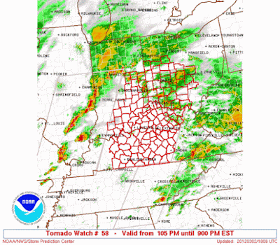
It didn't take long for things to ramp up. With the warm sector established across parts of KY, TN, IN, and IL (temps were near record highs for the time of year) and things already getting rolling the first tornado watch was issued at 9:30amCDT for central TN.
What was going to be a very long, tragic day was underway. Within 30 minutes a second tornado watch was issued, this time for far western KY, southern IL, western IN, and extreme southeast MO. Many of you who are chasers or weather enthusiasts will already know what PDS means but for those who don't: the Storm Prediction Center tagged this tornado watch with PDS label which means "Particularly Dangerous Situation". It's pretty self-explanatory what that means and these are only issued in rare instances, usually only once or twice per year. PDS would be used more than once or twice on this one day!

At this time, the mid-level shortwave was becoming negatively tilted and the speed max associated with it was nosing into the lower Ohio Valley while simultaneously strengthening to 100kts. A southwesterly low-level jet was also strengthening to 50-60kts as a result of the cyclone deepening. Coincident with this was the increasing instability due to both diurnal heating and moisture advection (sfc dew points of 60F plus, 850mb dew points of 12-15C). Long-lived supercells and violent tornadoes were possible, making matters worse was the fact that tornado potential was progged to rapidly increase even more into the afternoon.
Here is a portion of the SPC Discussion prior to PDS Tornado Watch: Valid 9:22amCDT
A RAPID INCREASE IN THE SEVERE STORM POTENTIAL APPEARS POSSIBLE BY
   MIDDAY...INCLUDING THE RISK FOR STRONG TORNADOES AND VERY LARGE
   HAIL.
 |
| 500mb RUC Analysis at 19z-20z via SPC Mesoanalysis Page |
 |
850mb RUC Analysis 19z-20z via SPC Mesoanalysis Page
|
By about 11:20amCDT, a broken segment of supercells devloped in southern IL and southeast MO, these particular cells were going to be a big deal in a couple of hours as it seemed very likely they were going to be interacting with a surface warm front. This often enhances lift, and streamwise vorticity (spin which is favorable for tornadoes).
The environment was extremely volatile by noon with high instability/steep lapse rates due to a very warm, moist warm sector. This was overlapped by extreme wind shear values with both speed and directional shear supportive of violent, sustained supercells and long-track tornadoes.
Actual Text from the tornado watch:
           ...THIS IS A PARTICULARLY DANGEROUS SITUATION...

      DESTRUCTIVE TORNADOES...LARGE HAIL TO 2.5 INCHES IN DIAMETER...
      THUNDERSTORM WIND GUSTS TO 70 MPH...AND DANGEROUS LIGHTNING ARE
      POSSIBLE IN THESE AREAS.
Henryville Tornadoes
At around 1:50pmCDT the lead cell produced tornado down near Fredericksburg, IN near Hwy 150.
As the tornado neared New Pekin it was still growing as it interacted with the aforementioned warm front.
Tremendous damage occurred which ranged from extensive tree/structural damage to reports of asphalt actually being stripped
from the roads. Within a minute or two reports came in that Henryville had been
devastated. Within just a few minutes large hail
began falling across town and the warning sirens sounded again. An EF1 tornado raced across town, just
South of the first tornado's path.
The EF4 that hit Henryville was on the ground for 49mi before finally lifting near Bedford, KY at 2:39pmCDT.
Over the course of its life it would weaken and re-intensify multiple times, from a violent wedge tornado
to a thin rope and back again. Unfortunately it took 11 lives as well.
 |
| Base Reflectivity Radar Image as the tornado moves into New Pekin, IN. Notice a distinct "hook echo" where precip is wrapping around the storm. The higher reflectivity in the end of the "hook" is debris from the tornado. |
 |
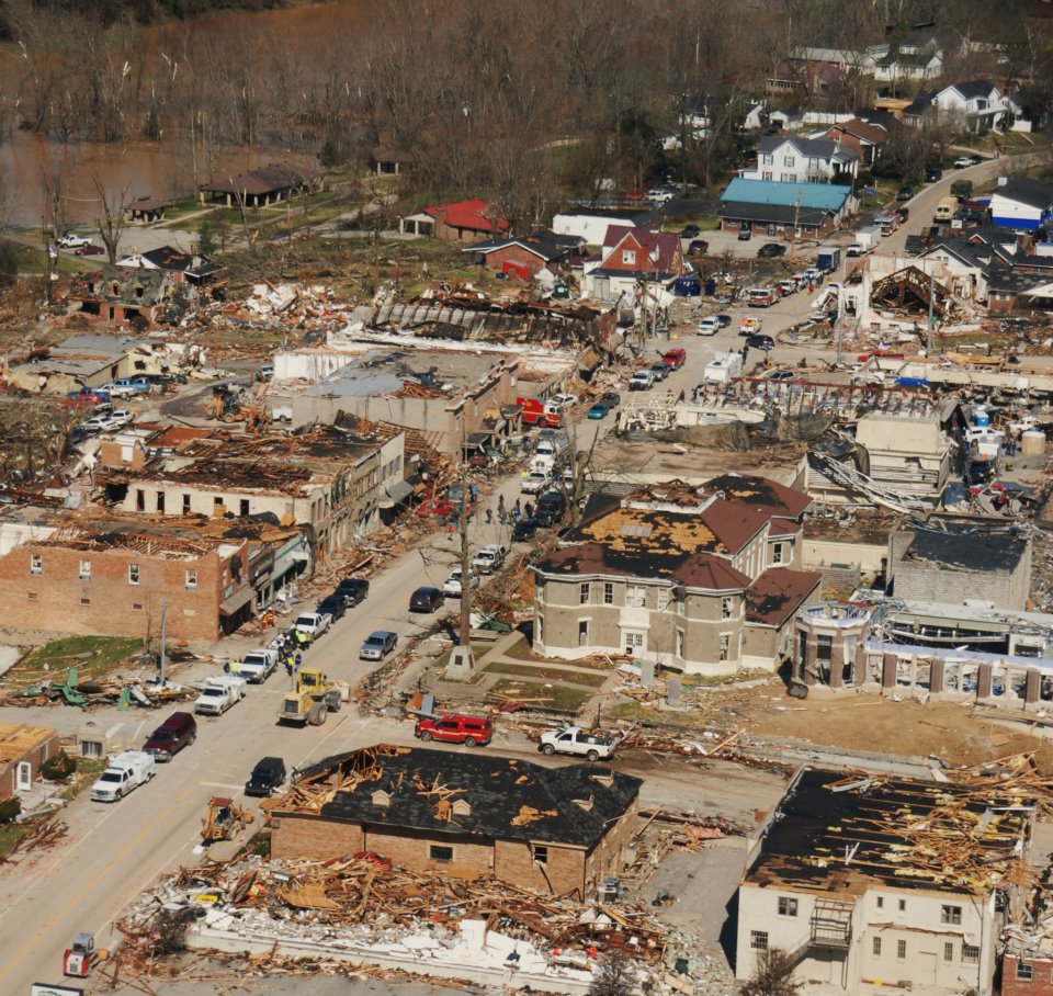
| Aerial photo of damage in Henryville, IN. (via NWS LMK Storm Survey) |
 |
| Significant Tornado Parameter at the time of the EF4 across southern Indiana |
 |
| 0-1km Storm-Relative Helicity at the time of the southern Indiana EF$ |
 |
| Radar showing a broken line of supercells along the Ohio River, which includes the "twin" supercells that will produce the tornadoes that will impact Henryville. |
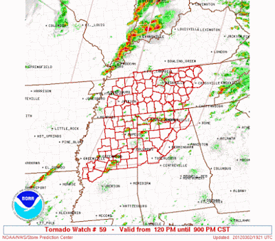
Violent storms continued to break out across the region. By mid-afternoon the SPC issued more tornado watches, including another PDS
watch across eastern Kentucky, to address the widespread storms extending from Ohio to Alabama.
West Liberty and Salyersville Tornadoes
This outbreak produced 70-81 tornadoes (varies depending on interpretation of damage paths).
Of those tornadoes 2 were EF4's and 9 were EF3's. Five of these EF3's occurred in Kentucky with one
of the EF4's occurring in KY as well. Even though instability was waning into the evening, extreme
wind shear values existed over eastern Kentucky. Plus, once storms are organized, especially supercells
which are essentially self-sustaining to a degree, it takes a lot less to keep them going than it does to
get them started.
 |
| Pictured above: Storm-Relative Helicity in the 0-3km and 0-1km levels as well as Siginificant Tornado Parameter during the time violent tornadoes were moving across eastern Kentucky.
|
Between 2:25-2:30pm CST a small updraft develops Northeast of Bowling Green, KY. Tracking northeastward,
this cell quickly became supercellular before turning eastward near Stanton, KY (supercell storms often turn right of the mean wind flow)
East of Stanton, it produced a tornado which rapidly intensified as the extreme wind shear caused it to rotate violently. Tracking eastward
it reached its highest rating, EF3, almost instantly as it devastated multiple small communities just North
of 460 leading to 2 fatalities. Then it emerged over a large hill and rolled directly into the center of West
Liberty, KY ripping right through downtown and destroying everything in its way. The damage here was
classified as high-end EF3. Reports indicate that 6 more people were killed in West Liberty but there were
numerous severe injuries. The tornado kept moving eastward despite terrain typically considered to
be unsupportive of tornadoes like this. It seems almost everywhere has a myth that some "hill protects their town from
tornadoes" or they "dissipate when they reach the river", etc. These are pretty much always false.
More EF3 damage was noted in Lawerence County near State Road 32. It then
tracked into West Virginia while maintaining its strength and destroying dozens of homes and businesses.
It finally dissipated after being on the ground for 86mi.
 |
| Radar loop of the supercells that produced the West Liberty and Salyersville, KY tornadoes (via GR3 radar software and NWS JKL) |
 |
| Radar images (Base Reflectivity & Storm-Relative Motion) of a tornadic supercell as it moves through the town of West Liberty, KY and nearby areas. (Images via Caleb Routt) |
 |
| West Liberty tornado track (via NWS JKL webpage) |

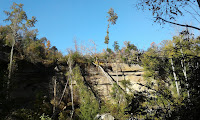
Pictured Above: Photos taken by me during an assessment of damage caused
by the tornado that impacted West Liberty, KY. The tornado actually traveled through
that valley for several miles, maintaining intensity while it did it. Notice that
trees are debarked and/or twisted.
 |
| Aerial photo of West Liberty, KY (via NWS JKL damage survey) |
 |
| Aerial photo of West Liberty, KY (via NWS JKL damage survey) |
It may have been the first EF3 in this part of the State in over 20 years but it wouldn't be the last one
that day. Just before 6pmCDT another tornado was spawned in Wolfe County, only about 15mi SE from
where the West Liberty tornado had initiated. It did some moderate damage to trees before exiting the county
to the East but it would also be able to take advantage of extreme wind shear and grow to sizes between
3/4-1mi wide. The tornado was at its maximum intensity when it struck the town of Salyersville, KY.
Over two-dozen injuries occurred here and substantial damage was observed. Some of the damage
appeared similar to what you would see with an EF4 tornado but given less-than-ideal construction
as a result of older buildings in eastern Kentucky it was rated EF3. In any case, some buildings were
completely obliterated. It continued eastward where it went in between destroying wooded areas and
small rural communities. EF2 damage was observed relatively consistently up until the tornado finally
dissipated after crossing into West Virginia. Two more fatalities during this outbreak were attributed to this
tornado along with over 30 injuries.
 |
| Radar images (Base Reflectivity & Storm-Relative Motion) of a tornadic supercell as it moves into and through Salyersville, KY. (Images via Caleb Routt) |
All in all there were 279 severe weather warnings issued by NWS offices on this day.
This was a well-forecast event from an operational perspective with outlooks highlighting the potential days in advance,
watches in place hours before, strongly worded public messaging, and warnings with an average lead time
of 28.6min (via IEM storm-based warning verification).
A big thanks to Caleb Routt for helping with some of the radar imagery, and to the page @I-65Weather on X for
additional insight.


No comments:
Post a Comment